| ALLIED GEOGRAPHICAL SECTION Southwest Pacific Area TERRAIN HANDBOOK 37 ROMBLON - MARINDUQUE (PHILIPPINE SERIES) 13 NOVEMBER 1944 |
General Headquarters,
Southwest Pacific Area,
13 November 1944 .
This Handbook contains information on the
Romblon-Marinduque Area as defined in the Orientation
Map. It is intended to provide basic topographical
information of military interest for the use of officers in
forward areas. The maps included are intended as guides
only, to be used in conjunction with operational maps.
By command of General MacARTHUR.
R. K. SUTHERLAND,
Lieutenant General. U.S.A.,
Chief of Staff.
Official:
C. A. WILLOUGHBY,
Brigadier General,' G.S.C ..
Asst. Chief of Staff, G-2.
CONTENTS
Area described in this Handbook is the islands of Roniblon Province, Semirara Is and Marinduque.
PART A describes the islands of Romblon Province and Semirara I. Each island is covered separately
and entirely in sub-sections.
PART B describes Marinduque.
PART C covers the medical and meteorological sections common to, the entire area.
PART B-MARINDUQUE
Section
1. INTRODUCTION AND GENERAL DESCRIPTION:
1. Location and Area Covered 41
2. General Description 41
3. Offshore Conditions 41
4. Physiography 42
5. Vegetation 42
6. Military Importance 42
7. Distances from Boac 43
8. Magnetic Variation 43
9. Standard Time and Measurements 43
10. Water Supplies 43
2. DETAILED DESCRIPTION OF COASTLINE:
1. San Andres Pt to Boac R 44
2. Boac R to Obung Pt 47
3. Obung Pt to Buenavista 49
4.. Buenavista to Marlanga B 51
5. Marlanga B to Salomague Pt 52
6. Salomague Pt to Santa Cruz Pt 53
7. Santa Cruz Pt to San Andres Pt 55
Landing Beach Summary Between pages 54 and 55
3. ROADS AND TRAILS:
1. Roads 56
2. Trails 57
4. TOWNS AND POPULATION:
1. Towns 58
2. Population and Language 59
3. Administration 60
5. AIRFIELDS, POSSIBLE SITES AND SEAPLANE BASES:
1. Airfields 61
i. Operational (none) 61
ii. Pre-war (none) 61
2. Possible Airfield Sites 61
3. Seaplane Bases 62
6. RESOURCES:
1. Foodstuffs 63
2. Forage 63
3. Fuel 63
4. Construction Materials 63
5. Labor Supply 63
6. Mineral Resources 63
7. Water Supply 64
8. Transport Facilities 64
PART C-GENERAL
1. MEDICAL PROBLEMS:
1. General 65
2. Diseases 65
2. METEOROLOGICAL CONDITIONS:
1. Climatic Types 67
2. Typhoons 67
3. Winds 67
4. Rain 67
5. Cloud 68
6. Visibility 68
7. Temperature 68
8. Earthquakes 68
APPENDIX "A"
4. Times of Sunrise and Sunset (Boac) 72
5. Times of Moonrise (Boac) 73
6. Times of Moonset (Boac) 74
APPENDIX "B"
Gazetteer of Place Names 75
APPENDIX "C"
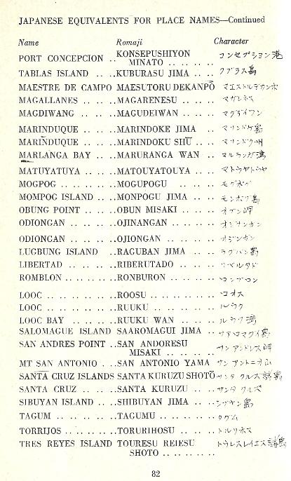
Japanese Equivalents of Place Names 81
Area described in this Handbook is the islands of Roniblon Province, Semirara Is and Marinduque.
PART A describes the islands of Romblon Province and Semirara I. Each island is covered separately
and entirely in sub-sections.
PART B describes Marinduque.
PART C covers the medical and meteorological sections common to, the entire area.
PART B-MARINDUQUE
Section
1. INTRODUCTION AND GENERAL DESCRIPTION:
1. Location and Area Covered 41
2. General Description 41
3. Offshore Conditions 41
4. Physiography 42
5. Vegetation 42
6. Military Importance 42
7. Distances from Boac 43
8. Magnetic Variation 43
9. Standard Time and Measurements 43
10. Water Supplies 43
2. DETAILED DESCRIPTION OF COASTLINE:
1. San Andres Pt to Boac R 44
2. Boac R to Obung Pt 47
3. Obung Pt to Buenavista 49
4.. Buenavista to Marlanga B 51
5. Marlanga B to Salomague Pt 52
6. Salomague Pt to Santa Cruz Pt 53
7. Santa Cruz Pt to San Andres Pt 55
Landing Beach Summary Between pages 54 and 55
3. ROADS AND TRAILS:
1. Roads 56
2. Trails 57
4. TOWNS AND POPULATION:
1. Towns 58
2. Population and Language 59
3. Administration 60
5. AIRFIELDS, POSSIBLE SITES AND SEAPLANE BASES:
1. Airfields 61
i. Operational (none) 61
ii. Pre-war (none) 61
2. Possible Airfield Sites 61
3. Seaplane Bases 62
6. RESOURCES:
1. Foodstuffs 63
2. Forage 63
3. Fuel 63
4. Construction Materials 63
5. Labor Supply 63
6. Mineral Resources 63
7. Water Supply 64
8. Transport Facilities 64
PART C-GENERAL
1. MEDICAL PROBLEMS:
1. General 65
2. Diseases 65
2. METEOROLOGICAL CONDITIONS:
1. Climatic Types 67
2. Typhoons 67
3. Winds 67
4. Rain 67
5. Cloud 68
6. Visibility 68
7. Temperature 68
8. Earthquakes 68
APPENDIX "A"
4. Times of Sunrise and Sunset (Boac) 72
5. Times of Moonrise (Boac) 73
6. Times of Moonset (Boac) 74
APPENDIX "B"
Gazetteer of Place Names 75
APPENDIX "C"
Japanese Equivalents of Place Names 81


Part B. MARINDUQUE ISLAND
SECTION 1
INTRODUCTION AND GENERAL DESCRIPTION
(Maps 9, 10)
1. LOCATION AND AREA COVERED.
This section (Part B) of HB 37 deals with Marinduque Province, located between 13° 12’ and 13° 34’ N
and 121°49’ and 122° 09’ E.
2. GENERAL DESCRIPTION.
Marinduque I, with an area of 346 sq mIs, is 13th comparable in size with Basilan I (Zamboanga) and
Jolo I. (Sulu Archipelago).
Its closest approach to Luzon is across an 11 ml wide Mompog Pass, to Mindoro 28 mls SW across
Tablas Str.
Situated at E entrance to Verde I passage, Marinduque is nearly circular; has a greatest diameter of
about 24 mls NW/SE.
Fairly well constructed gravel road encircled the island, and was well used along the west coast. There
were no airfields constructed, before 1941.
3. OFFSHORE CONDITIONS.
Depths:
Between Pamuntangan Pt (S point of Port Balanacan) and,Buenavista shoreline is, generally speaking,
clean and steep-to, with a small 4 3/4 fm patch the only detached danger. (In channel between Tres
Reyes I and mainland).
From Marlanga B to Salomague Pt shoreline is reef·fringed but in most places the 20 fm curve is within
1/4 ml of the shore.
The Salomague Pt-Pamuntangan Pt section is rough, irregular, broken by many bays, three of which,
Balanacan, Santa Cruz and Masagasai B are sheltered harbors.
Currents:
Tide rips west of San Andres Is - NW tip of Marinduque. Currents swift in Marinduque - Elefante I
passage.
Tide-Streams:
Branch of the Verde I (China Sea) stream passes NE around Tayabas B, N and E of Marinduque
through Mompog Pass, reuniting with other branch which passes SE along Mindoro coast then E, south
of Marinduque to Bondoc Pen, where it meets, the San Bernardino Str stream.
Winds, Typhoons, etc:
See Part C; General Sub Sec 2, Meteorological.
Tide Range:
Port Torrios Port
Balanacan Bay Santa Cruz
Datum (Mean LLW). 0 0 0
HW Interval 11 hr 25 m 11hr 25m 11hr 30m
Higher HW height +4.9 ft +5.2 ft +5.0 ft
Lowest Tide -1.5 ft -1.5 ft -1.5 ft
4. PHYSIOGRAPHY.
Terrain is generally mountainous and dissected, and unfavorable to movement. Northern group of
mountains contains several peaks more than 2000 ft high, located in central and western parts of the
island. Southern group with a general NW/SE trend also attains heights of over 2000 ft, and culminates
in southern circular headland occupied by the extinct volcano, Mt Marlanga (3876 ft)
Westwards the mountains come down close to the coast to leave a narrow but continuous belt of plain
1/4 to 1/2 ml wide. To the east and north the terrain falls more gradually to a zone of foothills, which come
down to the shore to leave only small areas of lowland between headlands. Small islands off the NE
coast low and level, with the exception of Mompog which is hilly in its eastern half.
Movement throughout island is generaly difficult and restricted to narrow coastal plain. Coastal road cuts
across southern promontory by low depression along northern foot of Mt Marlanga.
5. VEGETATION.
Mainly forest, grassland and cultivated crops. Primary and secondary forest mainly on the northern and
southern ranges. Grassland in patches throughout but especially in southern part.
Cultivated crops, predominantly coconuts and rice, with small quantities corn, abaca and sugar cane.
Cultivated crops in 1939 occupied about 30% of island. Coconuts are grown throughout the island, and
rice is restricted to western lowland flats. Rice paddies will hamper movement from Apr through to Sep.
6. MILITARY IMPORTANCE.
Strategic importance of Marinduque I would appear to lie in the degree of assistance it could give to an
attack on SE Luzon –
a. as an air base or
b. as a supply base
Possible airfield areas at Boac and Mogpog were photographed and proposed before the war but no
development was undertaken.
Gravel –surfaced road encircling the island would assist occupying forces, especially where it parallels
the tactical landing beaches of the westcoast.
Movement in the interior would be possible only for troops on foot.
Although both Masagasai B and Port Balanacan have been suggested as emergency seaplane
anchorages, Santa Cruz Hr is the only site recommended in the Naval Air Pilot (1937).
7. DISTANCES FROM BOAC
To enemy bases tat Mls Geog Mls
Davao 500 425
Manila 100 85
Legaspi 125 105
Formosa 675 575
To Allied bases
Tacloban 255 215
Peleiu 950 805
Morotai 900 795
Hollandia 1675 1425
8. MAGNETIC VARIATION
In Tayabas B, USC & GS Chart 4272 gives a variation of 1degree 00’ E (1944). Annual increase 1’.
(Lat. 13 degrees 40’ N. Long 121 degrees 53’ E)
9. STANDARD TIME AND MEASUREMENT:
Standard time on Marinduque is that of 120th Meridian, 8hrs. ahead of GMT.
Metric system was used throughout the PI. For this Handbook measurements are according to British
system. Heights shown in meters Manila C & GS Sheet 8, have been converted to ft.
10. WATER.
Annual rainfall was about 80 ins. A few towns had partly developed supply systems; elsewhere, rivers
and wells. Supply should be no problem.
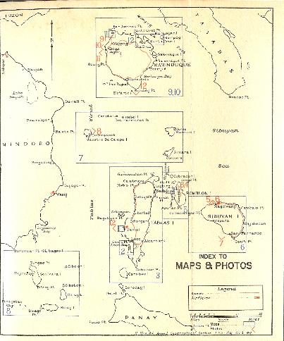
MAPS
Index to Maps and Photos Preceding Page 1
Orientation Maps Preceding Page 1
PART B MARINDUQUE
9. Marinduque 41
10. Physiography Map 42
11. Port Balanacan 46
12. Santa. Cruz Hr 54
PHOTOGRAPHS
PART B-MARINDUQUE
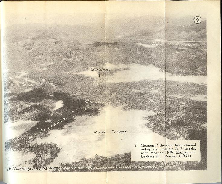
9. Mogpog R, showing flat-bottomed valley and possible A/F terrain, near
Mogpog, NW Marinduque. Looking S. Pre-war
(1935) 46 and 47
10. Boac R valley, possible A/F terrain, town of Boac, Provincial capital of Marinduque.
Looking E. Pre-war (1935) 46 and 47
11. Typical coconut palm hinterland of many W coast beaches. Offshore view of Laylay.
Pre-war 48 and 49
12. Volcano at S end of Marinduque I. Looking N. Pre-war 50 and 51
Index to Maps and Photos Preceding Page 1
Orientation Maps Preceding Page 1
PART B MARINDUQUE
9. Marinduque 41
10. Physiography Map 42
11. Port Balanacan 46
12. Santa. Cruz Hr 54
PHOTOGRAPHS
PART B-MARINDUQUE
9. Mogpog R, showing flat-bottomed valley and possible A/F terrain, near
Mogpog, NW Marinduque. Looking S. Pre-war
(1935) 46 and 47
10. Boac R valley, possible A/F terrain, town of Boac, Provincial capital of Marinduque.
Looking E. Pre-war (1935) 46 and 47
11. Typical coconut palm hinterland of many W coast beaches. Offshore view of Laylay.
Pre-war 48 and 49
12. Volcano at S end of Marinduque I. Looking N. Pre-war 50 and 51


SECTION 2.
DETAILED DESCRIPTION OF COASTLINE
(Anti-clockwise)
(See Map 9)
1. SAN ANDRES PT to BOAC R-10 mls (Map 11, Photo 9)
Anchorages:
Port Balariacan-2 1/2 mls S of San Andres Pt – consists of two small protected anchorages for moderate
sized vessels. Entrance to Port Balanacan – 1 ¼ mls wide between Antagtacan Pt and Pamuntangan Pt –
obstructed by Agpitan, Ataa and Madumug Is and a detached reef patch. Anchorage areas are:
I. Outer Anch: E of Madumug I in 11fms, mud bottom
II. Inner Anch: By passing close W of Salvaria I. Depths 6-9 fms, mud bottom, S of Pig Pt. The narrow
entrance channel is about 90 yds wide and has a at least depth of 5 fms.
Wharf Accommodation
A T-shaped pier on Bacood Pt at the S. side of entrance afforded berth for ocean-going vessels calling for
iron ore. An automatic device lifted ore from storage bin directly into ships holds.
Off-Iying Islands:
San Andres Is are two small islands, each 130ft high, extending about 1 ml W of Silangan Pt. Connected
to each other and with mainland by reef exposed at LW. Tide rips occur W of these islands.
Agpitan and Atila Is lie on a detached reef 3/8 and 1/2 mi SSW of Antagtacan Pt respectively. A
prominent pinnacle rock is on outer edge of reef S of Ataa I.
Madumug I on N side of entrance to Port Balanacan is small and wooded, 145ft high. Fringing reef which
bares at LW, links it with land to N. On W side of island is a light-brown cliff about 90ft high. A· detached
reef with least depth 1/4fm lies 300 yds SW of Island.
Salvaria I on E side of entrance to inner basin of Port Balanacan is a pile of rocks with a few trees growing
on it. It is.steep to on its W side and is linked with land by shoal area to E.
Coastline:
San Andres Pt is a small, steep-to peninsula, from which the coastline goes 1 ml SW to flat, sandy
Silangan Pt. Shore reef extends out to embrace San Andres Is. To Antagtacan Pt the 100 yd-wide shore
reef continues. The 10fm line lies about 400 yds out.
Mangroves fringe much of the shores of Inner Basin at Port Balanacan. The bottom fronting the mangroves
is shallow and sandy.
About 300 yds of firm sand beach exposes at LW in front of Balanacan Light, which was locate 280 yds N
of Balanacan town. Depths increase rapidly from outer edge of this beach to the 10fm line.
Balanacan Town is 120 yds N of Balanacan river mouth on E side of the port. There is a flat sand beach
between the town and Salvaria Pt. Between Balanacan R and Pamuntangan Pt the S entrance point to
Port Balanacan, sand beaches, about 250 yds long, occur in coves. These beaches are fronted by shore
reef 50-100 yds wide.
Bacood Pt and a T-shaped wharf extending front it, lie midway between Balanacan and Pamuntangan Pt.
South of Pamuntangan Pt fringing reef continues with 10fm depths 800 yds out.
Ulan R discharges across a 800 yd reef-bank behind Ulan Pt; it is parallel to the shore for 800 yds south of
its mouth.
Luauan barrio 1 1/4 mls SSW of Ulan Pt lies on a triangular point formed by rivers discharging to the north
and south of the town. Much of the beach area is planted in coconut palms between here and Lupac Pt 2
¼ mls SW. Lupac Pt is low, flat and sandy.
Landing Beaches:
Beach No 1 between Luauan and Lupac Pt (2 1/2 mls). Exposed SW monsoon. (See Landing Beach
Summary at end of Sec. 2.)
Hinterland:
San Andres Pt, 866ft high is commencement of a hilly section of the W coastline which ends at Ulan B.
Between Ulan: Pt, and the Boac R mouth hinterland is low. Along this section the combination of a terrace
1/2 ml wide and valleys leading into the interior has produced some extensive flat areas, which are
possible airfield sites. (Photo9)
Rivers:
Ulan R rises near Mt Tapian (2202ft), and is mangrove-fringed near its mouth.
Mogpog R is reported to have a safe anchorage at its mouth for small boats. Bancas could penetrate only
100 yds.
Boac R rises in E interior and discharges through the W coast ,just south of Lupac Pt. At town of Boac the
banks of the river are 5-IOft high, stream bed, about 200ft wide and depths 2ft during dry season, 5ft
during wet. River divides 1 ml above mouth. Main stream empties through broad mouth, accessible to
bancas at HW. Steamers could not approach closer than 250 yds off river mouth.
The SW branch of river empties near Laylay.
Roads:
A fairly efficient road-net (gravel) links Boac with Buliasnin: (2 mls NNW) and Mogpog (2 1/2 NE). The
latter road parallels the SW trend of the coast from Mogpog to Boac at about 1 1/2 mls inland from the
shore.
Link-up from Balanacan is by a road which crosses the Ulan R about 1 ml from its mouth. From Mogpog a
road strikes to the coast at Luauan 1 1/2 mls.
Continuation of the Boac-Mogpog national highway goes SW from Boac to Laylay, E from Mogpog to
Santa Cruz.
(See also Sec. 3 Roads and Trails.)
Towns (or barrios):
Mogpog was the largest town, with 1412 inhabitants. It was center for a municipality of 12,132 persons.
Fewer than 1,000 people were located at Bulanacan, and Buliasnin
Largest of the coastal barrios. (See Sec. 4.)
Airfield Sites:
Mogpog locality may be suitable. (See Sec. 5.)
2. BOAC R to OBUNG PT - 7mls (Photos 10, 11)
Anchorages:
Laylay - a samll village on S bank at the mouth of Laylay R - is usual landing place for Boac. Anchorage in
12 - 15 fms 1/4 to 1/3 mile W of the light at inner end of landing at Laylay. Cautious approach is
necesssary because water shoals rapidly.
Wharf Accommodation:
Pier at Laylay was 300 ft long, of reinforced concrete. At LW only 2 ft depths are available at end of pier.
Motor launches called daily from Laguimanoc and one vessel called each week from Manila.
Offlying Islands:
None.
Coastline:
For 2 mls S of Boac R mouth there is an expanse of 2 mls of sand beach. Lighters unloaded onto the
beach in front of Laylay. About 150 yds within the 20 fm curve the bottom rises abruptly from 10 to 3 fms.
The 3 fm curve defines the outer limit of a sandy shelf rising gradually to the beach.
Vessels of 10 ft draft could approach to within 1,000 yds of the beach while 4 ft draft barges could probably
come right in at HW or LW. Extent of beach (above HW) varies between 50 and 100 ft. It is soft but is
reported traversable by MT.
From 1 1/2 mls S of Laylay a fringing shore reef becomes evident. It continues for more than a mile breaks
for a 1/2 mil, then resumes to within 1 1/4 ,ls N of Obung Pt.
Landing Beach:
(See Landing Beach Summary at end of this Section) Beach No. 2 Boac R to 1 1/2 mls S of Laylay -
sand beach 2 mls long.
Hinterland:
Coastal plain or terrace near Laylay is 1/4 to 1/2 mile wide, braodening where it merges with the valleys
leading west into the interior. (Photo 10) Most of the coastal plain is in coconut palms with rice paddies
on the valley floors. (Photo11) Coconut vegetation ascends the intermediate slopes of the hills bordering
the inner side of the plain.
Rivers:
Balaring R has only 1 ft over its bar at HW, and is not navigable. Large stones ar found at mouth of river,
River channel is stable.
Amoingon R is also shallow. Gravel is found on its bed.
Roads:
Coastal road (except between the pier at Laylay and the mouth of the Boac R) is 100 - 300 ft from the
beach. Area between the coastal road and the beach is flat and covered with coconut palms planted at
20ft intervals.
From Boac a gravel one lane all weather road leads in to Binunga – 8 mls SE, following approximate
course of Boac Valley.
From Laylay to Obung Pt the highway parallels the beach 100-200 yds inland. (See also Sec. 3, Roads
and Trails.)
Towns:
Laylay (Pop 1191) consisted of several galvanised iron houses where copra and hemp were stored before
shipment. Road connecting Laylay and Boac was invariably in good condition.
Boac (Prov Capital) -See Sec 4, Towns and Population.
Largest barrios were - Bantay (Pop 1230) and Mainit (1433), both inland about 4 or 5mls WSW of Boac.
Possible Airfield Sites:
Boac locality may be suitable. (See Sec 5,)

OBUNG PT to BUENAVISTA - 11mls.
Anchorages:
Good anchorage, protected only from NE monsoon, in 7 or 8 fms Sandy bottom, about 3/8 ml W of Gasan,
or closer according to draft.
Offlying Islands:
Tres Reyes Islands consist of Gaspar (270ft), Melchor (250ft), and BaItasar (355ft) Islands which lie 2, 3
1/2 and 5 mls respectively WSW of Marinduque. Shores of these waterless uninhabited islands are clean
and steep-to, with the exception of Gaspar I, which has a coral fringe extending about 1/8 ml from its NE
point. Shore cliffs are precipitous and underworn. The SW side of each island has the highest cliffs. Least
depth in the channel between Gaspar and Marinduque is 4 ¾ fms, coastal steamers preferring the Melchor
–Gaspar pass.
Coastline:
Shoreline is clear from Obung Pt to Gasan (2 mls SE) offshore depths are constant. Town of Gasan is
situated on a slight bluff 20-50 ft high.
There is deep water offshore. It is considered possible for barges to land at any tide here. Coconut
groves back the beach. Beach length wouId be a mile both NW and SE of the town.
Except for the 4 ¾ fm patch on the north side of the channel between Marinduque and Tres Reyes I, the
west coast is steep-to.
The villages of Gasan, Daiquitin, and Buenavista are the most important along the road skirting the coast
between Obung Pt and Buenavista.
Best landing beach is along the 3mls of beach WNW of Buenavista, with foreshore 50-100 ft wide, firm
enough for MT. Above HW mark is 50 ft of rather soft sand. Tendency is for a 5 ft high sand bank to form
on the inland side of the beach, but this is not continuous, flattening out at the N end. At HW, 4 ft draft
barges should be able to land without difficulty.
Landing Beaches: (See Landing Beach Summary at end of this Section.)
Beach No. 3 - Gasan.
Beach No. 4 – Daiquitin – Buenavista.
Hinterland:
Most prominent building in Gasan town is a white coral warehouse with an iron roof. Immediately behind
the town is a hill upon which stands a ruined fort. Copra is the chief export of this area.
Mt.Gasan (1900 ft) lies 5 mls E of Obung Pt, Mt.Catala (1920 ft) 5 mls ESE of Gasan.
Toward the center of the island terrain becomes more mountainous, dominant peak being Mt..San Antonio
(2859 ft).
Elevations of 200 ft approach close to the shore near Catala Pt 6 mls SE of Obung Pt.
Between Catala Pt and Buenavista the bank bordering the beach is a firm flat area planted irregularly with
coconut trees with open grassy spaces between trees. The coastal road runs from 100 to 300 ft behind
the beach. The coconut covered hills start about 1/2 ml inland.
Behind Buenavista an abnormally large flat area extends for about a mile. This flat area is also in coconut
trees.
Rivers:
None is navigable.
Roads:
Section of the Buenavista - Boac highway traverses this coastal strip close to the beach. Gravel and oiled
surface was wide enough for vehicles to pass at normal speeds. Several small streams were bridged, but
there were no large rivers.
Behind Buenavista the road passes inland north of Mt. Marlanga to Tigui, on Marlanga B.
Behind Gasan a branch road from Dili goes inland to Tiguion (1 1/2 mls), a barrio of 890 persons.
Towns:
There were no barrios of more than 1000 inhabitants. Largest were Gasan (see Sec 4 -Towns) and
Buenavista, a fishing village of 655 inhabitants.

4. BUENAVISTA to MARLANGA BAY – 13 mls (Photo 12)
Anchorages:
Marlanga B - about 4 mls SW of Torrijos B - was of no commercial Importance. It is too deep for
anchorage except in a limited space close to the S shore where 12-15 fms, sandy bottom is available 800
yds from the shore.
Elefante I - anchorage on a small shelf north of the island in 13fms, sandy bottom, with E tangent bearing
180 degrees (true). Tidal currents have considerable velocity in channel between islet and Marinduque.
Outlying Islands:
Elefante Islet – 3/8 ml S of Suban Pt S tip of Marinduque I is a small round rocky islet 1/4 ml in diameter,
sparsely wooded. It is 386 ft high, clean, and steep-to on all sides. Prominent landmark.
Coastline:
Rounded Mt MarIanga peninsula is steep-to and clear except for a small section of reef between
Buenavista and Metati Pt.
Suban Pt - the S point of Marinduque I is bold and clean. Marlanga Pt – is a bold clean headland 3 mls to
ENE.
East and SE coast of Marinduque has protection from the SW monsoon.
Although available information does not indicate the amount of sand beach at the head of MarIanga Bay,
near Tigui, depths offshore are steep, and a small party may be able to get ashore.
Hinterland:
Photo 12 shows Elefante I and the volcanic cone formation of 'Mt MarIanga rising rapidly behind Suban
Pt. At Marlanga Pt the headland is 920ft high, 400 yards from shore. Slope of the hinterland behind Tigui
is less steep.
Rivers:
None is navigable.
Roads:
Trail is shown on some maps extending from Buenavista to Lipata, behind Suban Pt, and along the coast
to Tigui where the Buenavista - Torrijos section of the provincial highway emerges from jts course N of Mt
Marlanga. (See Sec 3.)
Towns:
Largest of small barrios were - Libas (Pop 536), Malbog (366) and Tigui (935).
5. MARLANGA B to SALOMAGUE PT – 10 mls.
Anchorages:
Torrijos B – shelter for small craft except from south and east winds. Entrance point and side of bay are
fringed with coral, narrowing entrance channel to 300 yds, anchorage area to 250 yds, 7 – 8 fms, sand
bottom in center of bay.
Offlying Islands:
None.
Coastline:
Coastal trend from Suban Pt is NE to Salomague Pt. North of Marlanga B shore reef develops. The 20 fm
curve is ¼ ml from shore. Fringing reef broadens to 1/5 ml wide near Salmoague Pt.
Most of shoreline is steep, rocky, with a number of rocky headlands. Only sandy beaches are reputed to
be near Torrijos, where there are two beaches:
a. 2 mls long, not continuous, south of Torrijos, reef fronted with small cliff face at inner edge of beach.
Foreshore 50 – 100 ft wide.
b. At head of Torrijos B – 450 yds sand beach, depths 3 fms 80 yds out, 6 ft 40 yds out and about 200 –
300 yds width of sand. About 400 – 600 yds behind the beach the two streams, which discharge at each
end of beach, join. The deltaic interval so formed is inclined to be marshy.
Hinterland:
The coastal road is usually within 300ft of the shore south of Torrijos. Coconut trees, rocky ground and
timber patches may slightly impede movement to the road from the beaches. Steep sided hills, some
barren, some timbered, restrict the coastal plain to 500 ft wide. A number of small villages is found on this
narrow perimeter.
Rivers:
Small fordable streams are Cabuyo R (near Cabuyo barrio) and Marlanga R (near Torrijos).
Roads :
From Tigui at head of Marlanga B to within 3 mls of Salomague I before changing from NE to NW to
proceed inland to Matuyatuya. (See Sec 3.)
Towns:
All barrios had less than 1000 inhabitants, most 300 – 700.
6 SALOMAGUE PT to SANTA CRUZ PT - 10 mIs.
Anchorages:
a. Masagasai B is large irregular indentation in coast almost filled by Salomague I. Passage between
island and mainland is shoal in the center, but expanding at either end to irregularly shaped basin.
i. South end - difficult access around south end of Salomague I or by crossing 2 ½ fm reef fronting
entrance. Depth 4 – 7 fms.
ii. North end – safe and fairly roomy anchorage for small vessels in 4 or 5 fms. Mineral Resources Coy
operated a mine and milI on a zinc, lead, gold property near Matuyatuya. A former landing at Balabag,
north of anchorage at north end of bay, was probably the only access to interior.
b. Santa Cruz Hr formed by passage between Marinduque and Santa Cruz I, is safe, roomy; with excellent
holding ground. Is an important refuge harbor.
i. Main Anchorage: For 12 major ships in 600 yd berths, well protected from wind and sea. Good
anchorage in 9 fms, soft muddy bottom, with south tangent to Santa Cruz I bearing 91 degrees (true) and
west tangent to the same island bearing 335 degrees (true).
Landing Beaches:
None suitable.
Hinterland:
Inland from Masagasai B is a level plain reputedly the largest on the island. Much of this area is pasture
land, with some few coconut trees and rice paddies. Coastal road, passing 2 mIs west of Salomague Pt,
goes NW across this area to Santa Cruz.
Behind the fringing swamp-belt predominant vegetation is coconuts. Hills rise up steeply behind the
coastal plain.
Rivers:
.
Tagum R, larger and with a greater volume of water than Santa Cruz R, empties immediately east of that
river. At the mouth are extensive mudflats, bare at LW, and cut by a channel having a depth of only one
foot. It is used by native boats bringing out mangroves for firewood. This stream over its upper course
becomes the Nape R. This stream is crossed by the highway where its banks are low, the bottom sandy,
the bed 200 feet wide, and normal water depth about 2 ft.
Santa Cruz R, emptying into the SW part of Santa Cruz Hr, is very shoal, navigable only by small boats at
HW.
Roads:
From behind Salomague Pt the coast road is 1 1/2 mls inland to west of Masagasai B, farther inland south
of Santa Cruz Hr, but only a mile from the dock at the town of Santa Cruz. A good gravel road leads to the
jetty at the mouth of the river, another dirt-road to Buyabud wharf. Trails lead from Santa Cruz ·to
Calancan B on the north coast west of Santa Cruz Pt, and the main road goes NW then generally westward
across the island to Mogpog. (See Sec. 3.)
Towns:
Largest barrios are Matuyatuya (Pop 650), Dolores (1001) and Tagum (961).
Santa Cruz – see Sec 4 – Towns.
Anchorages:
Marlanga B - about 4 mls SW of Torrijos B - was of no commercial Importance. It is too deep for
anchorage except in a limited space close to the S shore where 12-15 fms, sandy bottom is available 800
yds from the shore.
Elefante I - anchorage on a small shelf north of the island in 13fms, sandy bottom, with E tangent bearing
180 degrees (true). Tidal currents have considerable velocity in channel between islet and Marinduque.
Outlying Islands:
Elefante Islet – 3/8 ml S of Suban Pt S tip of Marinduque I is a small round rocky islet 1/4 ml in diameter,
sparsely wooded. It is 386 ft high, clean, and steep-to on all sides. Prominent landmark.
Coastline:
Rounded Mt MarIanga peninsula is steep-to and clear except for a small section of reef between
Buenavista and Metati Pt.
Suban Pt - the S point of Marinduque I is bold and clean. Marlanga Pt – is a bold clean headland 3 mls to
ENE.
East and SE coast of Marinduque has protection from the SW monsoon.
Although available information does not indicate the amount of sand beach at the head of MarIanga Bay,
near Tigui, depths offshore are steep, and a small party may be able to get ashore.
Hinterland:
Photo 12 shows Elefante I and the volcanic cone formation of 'Mt MarIanga rising rapidly behind Suban
Pt. At Marlanga Pt the headland is 920ft high, 400 yards from shore. Slope of the hinterland behind Tigui
is less steep.
Rivers:
None is navigable.
Roads:
Trail is shown on some maps extending from Buenavista to Lipata, behind Suban Pt, and along the coast
to Tigui where the Buenavista - Torrijos section of the provincial highway emerges from jts course N of Mt
Marlanga. (See Sec 3.)
Towns:
Largest of small barrios were - Libas (Pop 536), Malbog (366) and Tigui (935).
5. MARLANGA B to SALOMAGUE PT – 10 mls.
Anchorages:
Torrijos B – shelter for small craft except from south and east winds. Entrance point and side of bay are
fringed with coral, narrowing entrance channel to 300 yds, anchorage area to 250 yds, 7 – 8 fms, sand
bottom in center of bay.
Offlying Islands:
None.
Coastline:
Coastal trend from Suban Pt is NE to Salomague Pt. North of Marlanga B shore reef develops. The 20 fm
curve is ¼ ml from shore. Fringing reef broadens to 1/5 ml wide near Salmoague Pt.
Most of shoreline is steep, rocky, with a number of rocky headlands. Only sandy beaches are reputed to
be near Torrijos, where there are two beaches:
a. 2 mls long, not continuous, south of Torrijos, reef fronted with small cliff face at inner edge of beach.
Foreshore 50 – 100 ft wide.
b. At head of Torrijos B – 450 yds sand beach, depths 3 fms 80 yds out, 6 ft 40 yds out and about 200 –
300 yds width of sand. About 400 – 600 yds behind the beach the two streams, which discharge at each
end of beach, join. The deltaic interval so formed is inclined to be marshy.
Hinterland:
The coastal road is usually within 300ft of the shore south of Torrijos. Coconut trees, rocky ground and
timber patches may slightly impede movement to the road from the beaches. Steep sided hills, some
barren, some timbered, restrict the coastal plain to 500 ft wide. A number of small villages is found on this
narrow perimeter.
Rivers:
Small fordable streams are Cabuyo R (near Cabuyo barrio) and Marlanga R (near Torrijos).
Roads :
From Tigui at head of Marlanga B to within 3 mls of Salomague I before changing from NE to NW to
proceed inland to Matuyatuya. (See Sec 3.)
Towns:
All barrios had less than 1000 inhabitants, most 300 – 700.
6 SALOMAGUE PT to SANTA CRUZ PT - 10 mIs.
Anchorages:
a. Masagasai B is large irregular indentation in coast almost filled by Salomague I. Passage between
island and mainland is shoal in the center, but expanding at either end to irregularly shaped basin.
i. South end - difficult access around south end of Salomague I or by crossing 2 ½ fm reef fronting
entrance. Depth 4 – 7 fms.
ii. North end – safe and fairly roomy anchorage for small vessels in 4 or 5 fms. Mineral Resources Coy
operated a mine and milI on a zinc, lead, gold property near Matuyatuya. A former landing at Balabag,
north of anchorage at north end of bay, was probably the only access to interior.
b. Santa Cruz Hr formed by passage between Marinduque and Santa Cruz I, is safe, roomy; with excellent
holding ground. Is an important refuge harbor.
i. Main Anchorage: For 12 major ships in 600 yd berths, well protected from wind and sea. Good
anchorage in 9 fms, soft muddy bottom, with south tangent to Santa Cruz I bearing 91 degrees (true) and
west tangent to the same island bearing 335 degrees (true).
Landing Beaches:
None suitable.
Hinterland:
Inland from Masagasai B is a level plain reputedly the largest on the island. Much of this area is pasture
land, with some few coconut trees and rice paddies. Coastal road, passing 2 mIs west of Salomague Pt,
goes NW across this area to Santa Cruz.
Behind the fringing swamp-belt predominant vegetation is coconuts. Hills rise up steeply behind the
coastal plain.
Rivers:
.
Tagum R, larger and with a greater volume of water than Santa Cruz R, empties immediately east of that
river. At the mouth are extensive mudflats, bare at LW, and cut by a channel having a depth of only one
foot. It is used by native boats bringing out mangroves for firewood. This stream over its upper course
becomes the Nape R. This stream is crossed by the highway where its banks are low, the bottom sandy,
the bed 200 feet wide, and normal water depth about 2 ft.
Santa Cruz R, emptying into the SW part of Santa Cruz Hr, is very shoal, navigable only by small boats at
HW.
Roads:
From behind Salomague Pt the coast road is 1 1/2 mls inland to west of Masagasai B, farther inland south
of Santa Cruz Hr, but only a mile from the dock at the town of Santa Cruz. A good gravel road leads to the
jetty at the mouth of the river, another dirt-road to Buyabud wharf. Trails lead from Santa Cruz ·to
Calancan B on the north coast west of Santa Cruz Pt, and the main road goes NW then generally westward
across the island to Mogpog. (See Sec. 3.)
Towns:
Largest barrios are Matuyatuya (Pop 650), Dolores (1001) and Tagum (961).
Santa Cruz – see Sec 4 – Towns.


7. SANTA CRUZ PT to SAN ANDRES PT – 11 mls.
Anchorages:
Depths of 22 fms were available in Sayao B, but depths closer in near Sayao were 12 fms. Anchorage
was little used.
Firewood was exported from Lusok in the SE arm of Calancan B. Beach was backed by mangroves, and
bottom was mud.
Offlying Islands:
Banot Is are a group at the east end of Calancan B. Hakupan, outer island of group, is 1 ml NE of
Trapichihan Pt, high and bold.
Shore:
Santa Cruz Pt, the west point of north entrance to Santa Cruz Hr, is more than 100 ft high, fringed to the
north by a narrow reef. No outlying dangers north of a line running east and west through Santa Cruz Pt,
with exception of 2 ½ fm patch about ½ ml NW of point, beyond which water deepens rapidly. Foul ground
extends about 3 mls ESE of Santa Cruz Pt, forms the west limit of north channel into Santa Cruz Hr.
Reef fringes mangrove – backed foreshore to Trapichihan Pt, west marker of Calancan B, which is foul.
To the west of this point Sayo B, fringed with rocks, is deep. San Andres Pt is steep-to, and reef – fringed.
Hinterland:
Except for small comparatively level areas behind Lusok, SE corner of Calancan B, and behind Sayao,
south shore of Sayao B, the coastline is backed by wooded hills averaging 700 ft about a mile from the
shore. Sections of coconut growth are found near Sayao and other populated places.
Mt Tapian (2202 ft) is 4 mls inland south of Calancan B. Some of the ridges between it and the coast are
more than 1000 ft high. Mountains approach closest to the sea SW of Sayao B, where there is one of
1305 ft height and at San Andres Pt one of 886 ft.
Rivers:
None is navigable.
Roads:
Although trails from the Santa Cruz - Mogpog highway extend to coastal barnos near Lusok and Sayao, the
main road passes 4 mls behind the shore, through hilly terrain.
Towns:
Largest villages were Dolores (1001) and Sayao (984); Lusok had only 508 inhabitants.
SECTION 3.
ROADS AND TRAILS
(Map 9)
1. - ROADS.
Good gravelled and oiled surface 1lane, all weather road extends completely around the island. It was
reported in good condition in 1941. One road extended from Boac into the interior. Property of Mineral
Resources Coy was connected to jetty on Masagasai B by a road (suitable for MT). Numerous bridges
and fords.
i. Provincial Highway:
a. Boac – Buenavista - 30 km,19 mls:
Distances given are from Boac.
Towns of some importance are Santol, 1.2 km (3/4 ml); Laylay (Port of Boac), 4.2 km (3 mls); Cawit, 9 km
(5.6 mls), and Gasan, 16.5km (10.2 mls).
Bridges from Boac to Gasan are good; Gasan to Buenavista less
permanent.
Road, for full distance, is along or near beach through coconut groves, 20ft wide gravel surface. Some rice
fields. Some low ridges are cogon covered. Most streams are fordable, usually to east of bridges.
Vehicles may pass at normal speeds.
b. Buenavista to Torrijos - 24 km, 14.9 mls:
Rather winding road passing north of Mt MarIanga to Tigui; north to Torrijos road is fairly level, close to
shore.
c. Torrijos - Santa Cruz - 28km, 17.4 mls:
Open level country near Matuyatuya, some steep grades near Santa Cruz and south of Matuyatuya.
d. Santa Cruz – Mogpog - 27km, 16.78 mls:
There is a number of grades as the road runs inland several miles from the north coast. Automobiles can
pass at normal speeds.
e. Mogpog – Boac - 4.5-km, 2.8 mls:
Numerous rice fields and coconut groves are traversed by the road in both the Mogpog and the Boac R
valleys. Intervening hills are about 200 ft high.
f. Balanacan – Boac -14.2 km, 9 mls:
Road in places is narrow about 1 - 2 mls from Balanacan where it winds through hills.
ii. Reported Roads:
Mogpog – Luauan
1 ½ mls of good gravel road runs WNW of Mogpog to Luauan at mouth of Mogpog R.
Boac – Binunga (Inland to SE)
Probably 1 lane seasonal a road is shown extending 8 ½ mls SE along the Boac R valley to Binunga.
Boac – Buliasnin
1 ½ mls of gravel road traverses level terrain to Buliasnin on west coast, 2 mls NNE of Lupac Pt.
Dili (1/2 ml NW of Gasan) – Tiguion
Road 1 ½ mls long goes inland east of Dili.
2. TRAILS (from Manila C & GS Map).
Trails are shown connecting Boac with Maybo, 4 mls SE, Payi (on Boac –Binunga Rd) with Timbo, 15 mls
SE on Buenavista – torrijos section of main highway, and Bol (at junction of Bol R and Boac tributary) with
Torrijos (across mountainous center of the island.
Minor trails laced the Matuyatuya, Masagasai B and Santa cruz Hr areas.
Scant information is available.
SECTION 4.
TOWNS AND POPULATION
1. TOWNS.
i. BOAC -13°37' N; 121* 50' E.
About 2 mls from mouth of Boac R.
Population:
Poblacion (Town area) 2,958, Municipality 20,977.
Description:
Located on rolling to level ground on the south bank of Boac R, the town is capital of Marinduque
Province. A large church of solid masonry is on a hilltop. Numerous buildings have concrete or stone
foundations. About half way between Boac and Laylay (port of the capital) is an open plaza about 1,000 ft
wide in which were provincial capital buildings.
Communications:
Sea - Concrete jetty at Laylay, small village on south bank of Laylay R near its mouth. Several galvanised
iron warehouses.
Road - Boac is focal point for island's road system.
Signals -Telephone linked Boac with Gasan and Torrijos (61.6 mls of line). Bureau of Posts had radio
station, and there was a cable connection to Lucena.
lndustry:
There was an ice-plant in the town. Copra and hemp were exported. Sawmill produced 1000 board feet
daily.
Electricity and Wuter Supply:
Boac had a 59kw diesel power plant.
Partially developed water system (pumping) yielded 165,600 gallons a day, serving 7000 peop!e.
ii. SANTA CRUZ - 13°29' N; 122°02’ E. ,
About 1 ½ mls from mouth of Santa Cruz R, discharging into Santa Cruz Hr, NE.coast of Marinduque.
Population:
Poblacion 4,450; municipality 24,537
Description:
Near pier at Santa Cruz are several masonry buildings and a church. About 1 ml from dock town begins.
In town are 20 – 30 adobe stone buildings. Concrete school, municipal center arid stone church. Town is
unusually hilly. Town of Santa Cruz was provincial capital when Marinduque was sub-province to Tayabas
in 1902.
Communications:
Sea - Excellent holding ground, good anchorage in Santa Cruz Hr. Small coastal steamers called off Port
Buyabud thrice weekly. Jetty at Santa Cruz R mouth, and at Buyabud.
Road – To Boac via Mogpog and Torrijos. Highway from end of jetty causeway to Santa Cruz.
Signals - Telephone to other towns.
Electricity and Water Supply:
A 25kw diesel power plant was operated at Santa Cruz.
Gravity water supply system served 158,400 gallons a day to population of 2,600.
iii. GASAN - '13'20'N; i21"51' E.
On west coast about 9 mls south of Boac. On a slight, bluff 20 -50 ft high.
Population:
Poblacion 1,786, Municipality 10,794
Description:
Most prominent building was a white coral warehouse with an iron roof. Town was a Spanish style
settlement with a stone church on hill. Copra is chief article of export.
Communication:
Sea – Anchorage off town.
Road – Boac-Laylay-Gasan-Daiquitin, passes through Gasan to Buenavista; is important avenue of
communication, extensively used.
Signals: Telephone communication.
Electricity and Water Supply:
No power source. Water supply was by a partially developed pumping system giving 144,000 gallons a
day to population of 1,400.
Less important towns:
Buenavista (west coast), center of Buenavista municipality (Pop 655)
Mogpog (1412) NW of Boac, and Torrijos (1000) on SE coast.
2. POPULATION AND LANGUAGE
Population of Marinduque Province in 1939 was 81,768, distributed
through 150 barrios and in six poblacions. Concentrations were at Boac (2958), Gasan (1786), Mogpog
(1412), and Santa Cruz (4450).
Availability of labor (male Filipinos 15 – 45yrs ) and population per municipality, are shown in the following
table.
Municipality Population Labor Supply
Poblacion Municipal Male (15-45)
Boac 2958 20,977 4510
Buenavista 655 4,354 893
Gasan 1786 10,794 2291
Mogpog 1412 12,132 2730
Santa Cruz 4450 24,537 4882
Torrijos 1000 8,974 1835
Tagalog dialect was most used.
The European community was negligible; Asiatics comprised 557 Chinese, six Japanese.
About 60% of the inhabitants were able to read and write. Country was agriculturally inclined, nost of the
people being employed in the rice and coconut industries.
3. ADMINISTRATION:
Pre-war:
Classified as a Visayan Province, Marinduque had the normal government setup - a Provincial Board
consisting of a governor and two members elected by the people. Local government of PI consisted of 48
provinces and 12 chartered cities. The provinces, apart from chartered cities within their boundaries, were
divided into municipalities, then into poblacions and into numerous barrios. The poblacion, always the
municipal administrative center, and usually the largest town in the area, consisted of two or more barrios.
Boac town was a Philippine Constabulary center. Boac was capital of the province, and there were six
municipalities on the island.
Under Enemy Occupation:
Province was reverted to control of Tayabas Province, Luzon
(Marinduque was a sub-province of Tayabas in 1902 with Santa Cruz as its provincial capital).
SECTION 5.
AIRFIELDS, POSSIBLE AIRFIELD SITES AND SEAPLANE BASES.
1. AIRFIELDS.
i. Operational –
None
ii. Prewar Airfields –
None
POSSIBLE AIRFIELD SITES.
General.
Locations at Mogpog and Boac were recommended as sites for airfields before the war. Existing
photographs – Mogpog (Photo 9) and Boac (Photo 10)
indicate good possibilities in these two areas.
i. NW Marinduque I.
Flat-floored valleys traversed by the Mogpog and Boac Rs provide scope for A/F· development. This
combination of coastal terrace and valleys leading into the interior is the most likely A/F terrain on the
island. Facilities of two of the largest towns – Boac (provincial capital) and Mogpog would be available.
Boac and Mogpog Rs are reported fordable in dry season with seldom more than 5 ft depth near the town
even in wet season. Nearest sheltered anchorage is Port Balanacan - 4mls north of Mogpog and 6 mls
NNE of Boac. Vessels for.Boac unloaded to beach and landing at LayIay.
ii. East Marinduque (Matuyatuya).
Although this area near Matuyatuya is reported to be the largest level area on the island, it is badly served
with other than road communication. Inferior port facilities are located at Santa Cruz and Masagasai
(loading jetties, served by lighters).
iii. West coast-Buenavista .
Valley 1 mile long extends inland behind Buenavista. Potentialities of this area are not· known.
iv. NE coast-Maniuayan I.
Reported as low and flat, this island is approximately 4000 yards long fringed by coral reef with small cliff
faces at its NW end. Main vegetation cover is coconuts.
3. SEAPLANE BASES.
General.
Only harbor with potential value for seaplanes is Santa Cruz Hr on the NW side of Marinduque.
(Emergency all weather seaplane anchorage)
i. Santa Cruz Hr - 13°30' N; 122°04' E.
Location:
Anchorage adjacent to south shore of Santa Cruz Hr at mouth of Santa Cruz R. Depth 3 - 30 ft.
Terrain:
Santa Cruz Hr is formed by passage between Marinduque and Santa Cruz I; is safe and fairly roomy.
Santa Cruz R is shoal, navigable only by small boats at HW. Town lies 1 1/2 mls from river mouth. Road
links town and river.
Runways:
WNW /ESE, 2 1/2 mls.
NNW /SSE, 2 mls.
Currents:
During flood tide a weak current sets in through the north channel and out through the east channel,
conversely during ebb.
Tender Anchorage:
See Sec 2, Para 6. Anchorages.
Remarks:
Important harbor of refuge. No beaches, but warehouse and small wharf at Santa Cruz R mouth.
Emergency seaplane anchorages could also he had in Port Balanacan and Masagasai Bay.
SECTION 6.
RESOURCES.
No surplus of food was produced on the island. Copra,hemp and firewood were exported, however, and
mining operations were developing before the war.
1. FOODSTUFFS:
In 1938 the island produced -
Palay 129,381 cavans
Corn 3,010 cavans
Camotes 417,581 kilos
Cassava 23,679 kilos
Coconuts (for food) 1,116,477 nuts
Conversion:
1 cavan palay eqnals 94.77 lbs.
1 cavan corn equals 128.93 lbs.
1 kilo equals 2.204 lbs.
Total number of cattle on farms in 1939 was 3,922. There were 13, 325 carabaos, 6,929 horses, 16,290
pigs and some goats. Fish were plentiful.
2. FORAGE:
Believe plentiful.
3. FUEL:
Firewood was exported at Lusok on the north coast. There are no known coal deposits.
4. CONSTRUCTION MATERIALS:
Along the road from Boac to Buenavista are ample gravel resources, and coral for crushing is available
from the beaches. Timber for repair or construction work is not plentiful along the coconut palm planted
coastline, but is more plentiful along the interior roads. Practically all creek beds would yield gravel for
surfacing.
A sawmill at Boac produced 1000 board feet daily.
5. LABOR SUPPLY:
A total of 17,141 males between 15-45 yrs.
6. MINERAL RESOURCES:
Marinduque Iron Mines near Mogpog were operated by the Japanese before the war. There were
2,000,000 to 3,000,000 tons blocked out. Production in 1940 was 125,500 tons of 62% ore.
Mineral Resources Coy operated a small mine and ill on a zinc, lead, gold property near Matuyatuya.
Copper prospects were operated up Boac R, within a mile or two of Marinduque Iron Mines; there were
promising copper outcrops at Torrijos.
7. WATER SUPPLY
Reputedly adequate. Water supply stations were at the following locations:
Population System Capacity
Served gal a day
Boac 7000 Pumping 165,600
Gasan 1400 Pumping 144,000
Santa Cruz 2600 Gravity 158,400
8. TRANSPORT FACILITIES:
Road system embraced 104 mls of graveled road surface, encircling the island.
Registration of vehicles (1940) was 52 automobiles, 4 trucks. (for road details see Sec. 3)
PART C – GENERAL
SECTION 1.
MEDICAL PROBLEMS
1. GENERAL
Islands of Romblon Province have a very short dry season and Marinduque has none, resulting in no
pronounced period of mosquito density. The rainfall is about 70 – 80 ins, and the mean annual
temperature about 82* F, making the climate tropical, humid and tending to be enervating.
2. DISEASES.
Malaria:
Available information does not mention any areas of severe incidence. Types met with are usually benign
tertian and subtertian.
Anopheline mosquitoes present include A barbirostris, A filipinae, A kochi, A ludlowi, A maculates, A
mangyanus; the most important vector is A minimus var. flavirostris, which breeds in bamboo grown
foothill streams.
Dengue:
This disease has a vector the mosquitoes Aedes aegypti and A albopictus.
Filariasis:
Sporadic cases of filariasis and elephantiasis are transmitted by mosquito Culex fatigans.
Dysentery:
The disease is common, bacillary types being more prevalent. The incidence is reported to have
increased since Japanese occupation.
CHOLERA: No report of an outbreak has been received. However, it is necessary for all troops to
maintain the highest practicable standards of hygiene as a precaution against the spread of this and other
enteric diseases.
Typhoid and Paratyphoid Fevers:
Fevers occur, but are less prevalent than dysentery.
Yaws (Framboesia):
Is common under poor hygienic conditions, but is seldom contracted by whites.
Scabies:
A common skin disease caused by the itch mite sarcoptes scabiei. Secondary hyogenic infection due to
scratching is often seen.
Fungus infections of skin:
Tinea craris (dhobie itch), seborrhoea and pityriasis are common and cause irritation and discomfort.
Tinea imbricata is less common.
Tropical Ulcers:
Cuts and abrasions easily become infected unless treated with antiseptic.
Venereal Diseases:
Gonorrhoea is more prevalent than syphilis, and is likely to have increased.
Tuberculosis:
The disease is very common.
Smallpox:
Was eradicated by vaccination of the natives.
Malnutrition and Deficiency Diseases:
Malnutrition and beriberi have increased under Japanese occupation due to lack of food supplies, poor
hygienic conditions and lack of treatment. It is estimated that 50% of Filipinos are undernourished.
Worm Infections:
Hookworm is endemic, although severe hookwarm anaemia is uncommon. Ascariasis is even more
prevalent and other varieties are encountered.
Hospital Facilities:
There was a resident doctor in Romblon, but no details known of any hospitals.
SECTION 2.
METEOROLOGICAL CONDITIONS.
1. CLIMATIC TYPES:
The area covered by this Handbook consists of one type of Philippine climate (Type C). There is no very
pronounced maximum rain period, with a very short dry season lasting from Jan to Apr. The islands are
only partly sheltered from the NE monsoon and trades, and are open to the SW monsoons.
2. TYPHOONS:
Typhoon's generally originate to the east and travel west or NW. Persistent gales, heavy squalls, torrential
rains from widespread overcast, low cloud and disturbed seas are experienced in the neighborhood of
typhoon centers.
Typhoons are quite frequent in the Sibuyan Sea -19 % of all typhoons occur there. The mean track of
typhoons moves progressively north from Feb to mid-Aug, and then south until Jan. Thus the west-moving
winter and spring typhoons generally strike the PI south of lat 15*N. From Jan to Mar the region north of lat
11*N is almost immune from typhoons.
3. WINDS:
The NE monsoon extends from Nov to Apr with winds between north and NE, becoming more easterly at
end of monsoon. When best developed in Jan, the monsoon blows with steadiness at15-20 mph.
The SW monsoon, following a transition period of variable winds and calms, prevails from June to Oct. It is
steadiest in Jul and Aug with the wind averaging 10-15mph.
Squalls are relatively frequent during SW monsoon, particularly near land, and the wind in such squalls may
reach gale force in gusts. Thunderstorms also occur.
Strong arid squally local winds, named callas, sometimes blow for several days in summer and early
autumn from the West and SW.
Land and sea breeze effect is unimportant
4. RAIN:
Rainfall data is as follows (monthly average in inches):
Odiongan -Jan 2.7; Feb 1.1, Mar O.9, Apr 1.7, May 6.9, Jun 9.9, Jul17.7; Aug I4.4, Sep 11.7, Oct 13.7, Nov
8.0, Dec 6.2. Yearly 94.9.
Romblon -Jan 4.6, Feb 3.6, Mar 2.2, Apr 2.6, May 5.5, Jun 8.7, Jul 11.8, Aug 8.5, Sep 9.6, Oct 12.6, Nov
12.0, Dec 8.8. Yearly 90.5.
Boac - Jan 3.3, Feb 2.7, Mar 1.6, Apr 2.7, May 5.7, Jun8.3, Jul 9.5 Aug 7.6, Sep 8.3, Oct 12.2, Nov. 10.1,
Dec 8.3. Yearly 80.1.
Rain days average 4 - 10 during the short dry season, and 15 - 20 during the wet season.
Abnormally heavy rainfall associated with typhoons may lead to serious fIooding. Torrential rain of short
duration occurs during thunderstorms.
5. CLOUD:
Cloud amount is relatively great. It is at a minimum in spring, being 3/10 to 5/10. In summer, cloud
exceeds 7/10. Seasonal trend follows rainfall, though spring minimum seems more pronounced than that
of rainfall. When SW winds blow uninterruptedly overcast skies of 1000 - 2000 ft base prevail.
6. VISIBILITY:
Visibility is generally good, fog being rare.
7. TEMPERATURE:
Temperature is consistently high, with maximum in Dec – Feb. About sea level, temperatures rarely
exceed 95* F or fall below 65* F. Humidity is high.
8. EARTHQUAKES
Disturbances have been reported, but are not frequent.
APPENDIX A
4. Sunrise and Sunset for Dec 44 – Apr 45.
BOAC - 13°27' N; 121°50' E.
Times shown are standard for Philippines.
(8 hrs ahead of GMT)
SUNRISE SUNSET
1944 1944
Dec Dec
6 0612 6 1728
13 0616 13 1731
20 0620 20 1734
27 0622 27 1739
1945 1945
Jan Mar Jan Mar
3 0626 7 0612 3 1742 7 1808
10 0628 14 0607 10 1746 14 1809
17 0629 21 0602 17 1749 21 1810
24 0629 28 0557 24 1754 28 1811
31 0628 31 1757
Feb Apr Feb Apr
7 0626 4 0553 7 1800 4 1811
14 0624 11 0548 14 1803 11 1812
21 0620 18 0543 21 1805 18 1813
28 0616 25 0539 28 1807 25 1815
5. Moonrise for Dec 44 – Apr 45.
BOAC - 13°27' N; 121°50' E.
Times shown are standard for Philippines.
(8 hrs ahead of GMT)
1944 1945
Date Dec Jan Feb Mar Apr
1 1845 2008 2118 1959 2102
2 1940 2051 2203 2045 2151
3 2035 2150 2249 2131 2243
4 2131 2238 2336 2218 2336
5 2221 2325 ------ 2306 ------
6 2311 ------ 0024 2357 0030
7 2359 0010 0114 ------ 0123
8 ------ 0057 0207 0049 0216
9 0046 0144 0302 0144 0307
10 0131 0233 0359 0240 0357
11 0208 0326 0456 0335 0446
12 0305 0421 0552 0429 0534
13 0353 0519 0645 0522 0623
14 0445 0615 0736 0612 0712
15 0539 0711 0825 0702 0804
16 0635 0805 0912 0748 0857
17 0731 0857 0958 0836 0952
18 0827 0946 1045 0925 1048
19 0921 1032 1132 1016 1144
20 1012 1116 1222 1108 1237
21 1101 1201 1314 1202 1329
22 1148 1248 1406 1256 1419
23 1233 1335 1500 1349 1507
24 1317 1424 1553 1442 1553
25 1402 1517 1646 1532 1638
26 1449 1611 1736 1622 1725
27 1539 1706 1825 1710 1812
28 1631 1759 1913 1756 1859
29 1726 1852 1842 1948
30 1821 1942 1927 2040
31 1917 2031 2014
6. Moonset for Dec 44 – Apr 45.
BOAC - 13°27' N; 121°50' E.
Times shown are standard for Philippines.
(8 hrs ahead of GMT)
1944 1945
Date Dec Jan Feb Mar Apr
1 0701 0825 0908 0743 0810
2 0759 0911 0944 0819 0851
3 0855 0954 1020 0855 0934
4 0946 1033 1057 0933 1022
5 1035 1111 1135 1011 1112
6 1118 1147 1216 1054 1206
7 1158 1223 1300 1139 1304
8 1237 1301 1348 1228 1402
9 1313 1341 1440 1322 1502
10 1350 1423 1537 1419 1603
11 1428 1510 1638 1519 1703
12 1506 1601 1739 1620 1804
13 1546 1657 1841 1722 1905
14 1632 1755 1942 1824 2007
15 1721 1856 2041 1924 2109
16 1811 1957 2145 2025 2211
17 1910 2056 2238 2124 2310
18 2008 2157 2336 2224 -------
19 2107 2301 ------- 2324 0005
20 2206 2347 0033 ------- 0056
21 2303 ------ 0130 0022 0143
22 2359 0044 0226 0118 0226
23 ------- 0140 0320 0210 0306
24 0056 0238 0412 0259 0344
25 0152 0335 0501 0344 0420
26 0249 0431 0545 0427 0456
27 0347 0525 0627 0506 0533
28 0445 0616 0706 0543 0611
29 0544 0705 0619 0651
30 0641 0748 0655 0733
31 0735 0829 0732
APPENDIX “B”
GAZETTEER OF PLACE NAMES
This gazetteer contains all place names mentioned in Handbook 37. Approximate location of each feature
is given on the respective islands.
Abbreviations: B – Bay; I – Island; Mt – Mountain; Pt – Point; R – River; V – Village or Town.
Place Name Feature Location by Coast Island or Group
AMOINGON V,R W Marinduque
BAGACAY V Central Marinduque
BALANACAN Port, V NW Marinduque
BALARING V,R W Marinduque
BALTASAR I SW Marinduque
BANOT I N Marinduque
BOAC R,V NW Marinduque
BOL V Central Marinduque
BUENAVISTA V SW Marinduque
BULIASNIN V NW Marinduque
CABUYO R E Marinduque
CALANCAN B N Marinduque
CATALA Mt, Pt SW Marinduque
CAWIT V W Marinduque
DAYKITIN V SW Marinduque
DOLORES V Central Marinduque
ELEFANTE I S Marinduque
GASAN V, Mt SW Marinduque
GASPAR I SW Marinduque
HAKUPAN I N Marinduque
LAYLAY V W Marinduque
LUAUAN V NW Marinduque
LUPAC Pt W Marinduque
MAINIT V Central Marinduque
MALBOG V Central Marinduque
MANIUAYAN I NE Marinduque
MARLANGA B,Pt,Mt SE Marinduque
MASAGASI B E Marinduque
MATUYATUYA V E Marinduque
MELCHOR I SW Marinduque
METATI Pt S Marinduque
MOGPOG R,V NW Marinduque
MOMPOG I NE Marinduque
NAPO R Central Marinduque
OBUNG Pt W Marinduque
SALOMAGUE I,Pt E Marinduque
SAN ANDRES Is NW Marinduque
SAN ANDRES Pt NW Marinduque
SAN ANTONIO Mt Central Marinduque
SANTA CRUZ I NE Marinduque
SANTA CRUZ Pt N Marinduque
SANTA CRUZ V N Marinduque
SAYAO B NW Marinduque
SUBAN Pt S Marinduque
TAGUM Pt NE Marinduque
TAGUM R NE Marinduque
TAPIAN Mt Central Marinduque
TIGUION V SW Marinduque
TIGUI V SE Marinduque
TIMBO V Central Marinduque
TORRIJOS B,V E Marinduque
TRAPICHIHAN Pt W Marinduque
TRES REYES Is SW Marinduque
ULAN Pt NW Marinduque