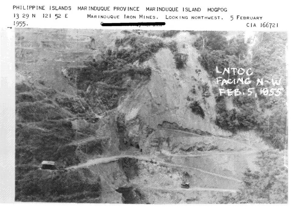
CIA Reading Room cia-rdp83-00423r001900700001-3: GOLD AND IRON MINING By CIA Reading Room Publication date 1955-05-11. 4. Landscape shot of Marinduque Iron Mines deposits.
NOTE: This has been declassified.

The History of Marinduque from Ulong Beach

CIA Reading Room cia-rdp83-00423r001900700001-3: GOLD AND IRON MINING By CIA Reading Room Publication date 1955-05-11. 4. Landscape shot of Marinduque Iron Mines deposits.
NOTE: This has been declassified.
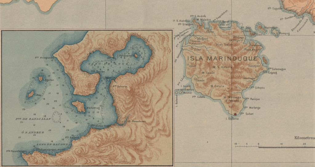
If you live in Marinduque or have ever visited the island you most likely have used the port facilities in Balanacan, Mogpog. You may also have taken a walk over to the statue of Our Lady of BIGLANG-AWA while waiting to board one of the ships. Hidden from view are the remains of Japanese warships that were sunk in the vicinity. What else could be hidden there? Maybe the true name of this harbor in Marinduque.
Did you know that Balanacan is not the original name of this area?
Although this port was recognized early on as a perfect area to shelter vessels, it was not widely used as a port of commerce until a paved road was completed in 1918. Up until that time only a dirt trail connected it with the nearest town, Mogpog.
Puerto de San Andres
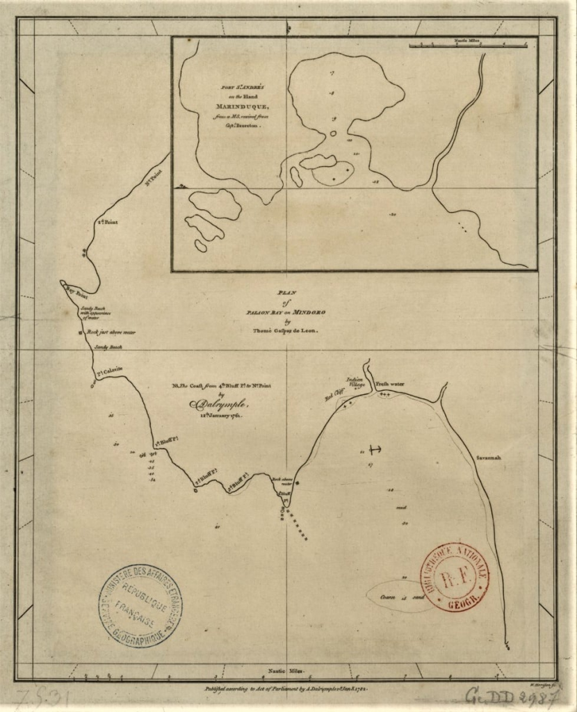
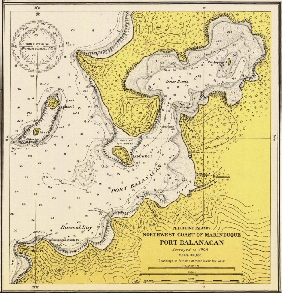
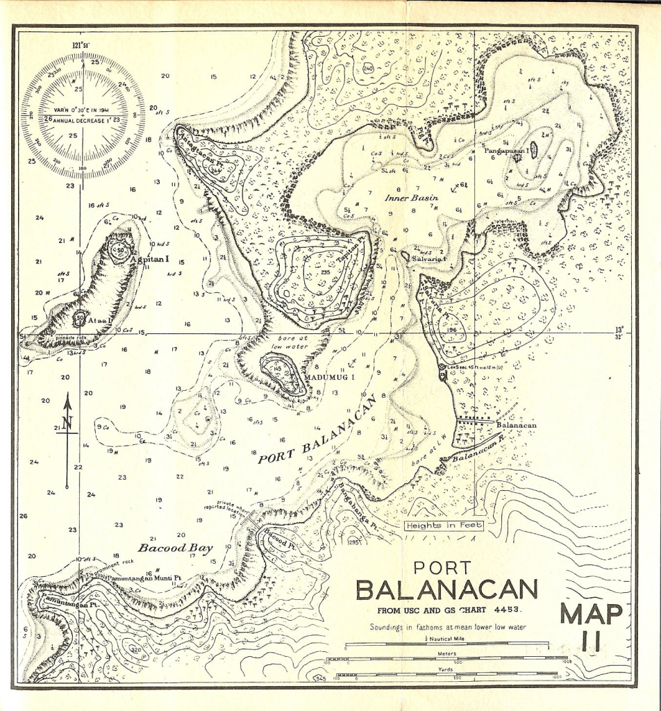
The first recorded name I could locate that is associated with this natural harbor area is that of Puerto de San Andres. The name was first published in a 1761 map by Captain William Brereton of the British Navy. It contains little detail other than soundings for the entrance channel. In a Spanish map from 1841 entitled De una parte de la cost sur de la Isla de Luzon we see the name and again it lacks detail but must be noted as important as it is one of only a few locations shown on the island of Marinduque.
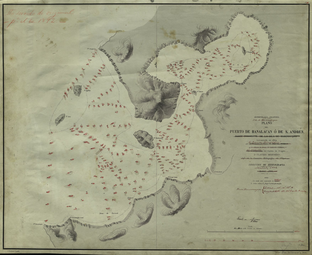
The name San Andres would be associated with the port up until the end of the 1800’s and could be found on Spanish maps from 1866, 1892 and a map from the Manila Observatory from 1899. The 1866 map is the first detailed map of the port with soundings, terrain features and place names.
Banalacan
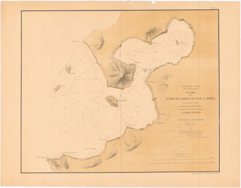
The second name that could be found was that of Banalacan which was first used in 1866 and was associated with Puerto San Andres and could be used as either/or up until 1899. The Spanish 1866 map is entitled Plano Del Puerto de Banalacan o de St Andres and as is noted in the section for San Andres is the first detailed map of the port with soundings, terrain features and place names.
The name is used again in the revised edition of this map from 1892. In a 1900 sketch of operations by Capt Robert Getty 1st Infantry United States Volunteers the spelling Banalacan is used by Americans local on the island. It should be noted that American forces were dependent of Spanish maps so most place names were taken from those maps.
In 1901 in a publication from the United States Board on Geographic Names relating to The Geographic Names in the Philippine Islands Banalacan is still used.
The last reference to Banalacan I could locate was in a 1908 publication from the U.S. War Department Annual Report, volume 8.
Banacalan
The third name to be found and the oddball of the group is that of Banacalan. It is first found in an undated map from the Norris Peters Company, Washington D.C. and is noted as taken from a Spanish survey in 1864 which would most likely be the Spanish 1866 map is entitled Plano Del Puerto de Banalacan o de St Andres.
The 1899 map from the Manila Observatory Atlas of the Philippine Islands also lists the port as Pto de Banacalan o San Andres. I could not locate any other uses of Banacalan and maybe is a misspelling of Banalacan that was being used at the time.
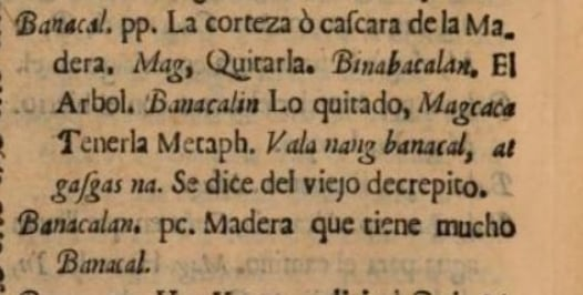
I did find Banacalan in the book entitled Vocabulario de la lengua Tagala written by the Jesuits in 1754. The English translation of the Spanish translation is “wood that has a lot of bark”.
If it is not a misspelling this may have some significance since there is speculation that the port was used by the Spanish to build and repair their Galleons.
Balanacan
The fourth name is what we know the port as today, Balanacan. When exactly and why the name was changed from the previous usage I could not determine.
The first use was found in the 1896 Spanish publication Catalogo Sistematico de Toda La Fauna De Filipinas. The first and subsequent use by the Americans was found in the publication of the 1903 Census of the Philippine Islands. It could be found again in the 1905 Annual Reports of the War Dept. Volume 12. The first American map to use Balanacan was the 1908 map produced by the US Geodetic Survey. Balanacan was still use found in the US Army Map 11 dated 1944 during World War 2.
Baranakan
I would call this a “interesting side note” since I did not find any use of Baranakan other than in the U.S. publication from WW2 Japanese Equivalents for Place Names.


Original video by creator
KAPROBINSYA and all credits to him.
Exploring and investigating Marinduque’s abandoned oldest cemetery in Boac.
https://youtu.be/3cKBcBdXy6s?si=BX8ajj0xa13AiUGs
and
Exploring and investigating Marinduque’s abandoned Spanish Wall Ruins
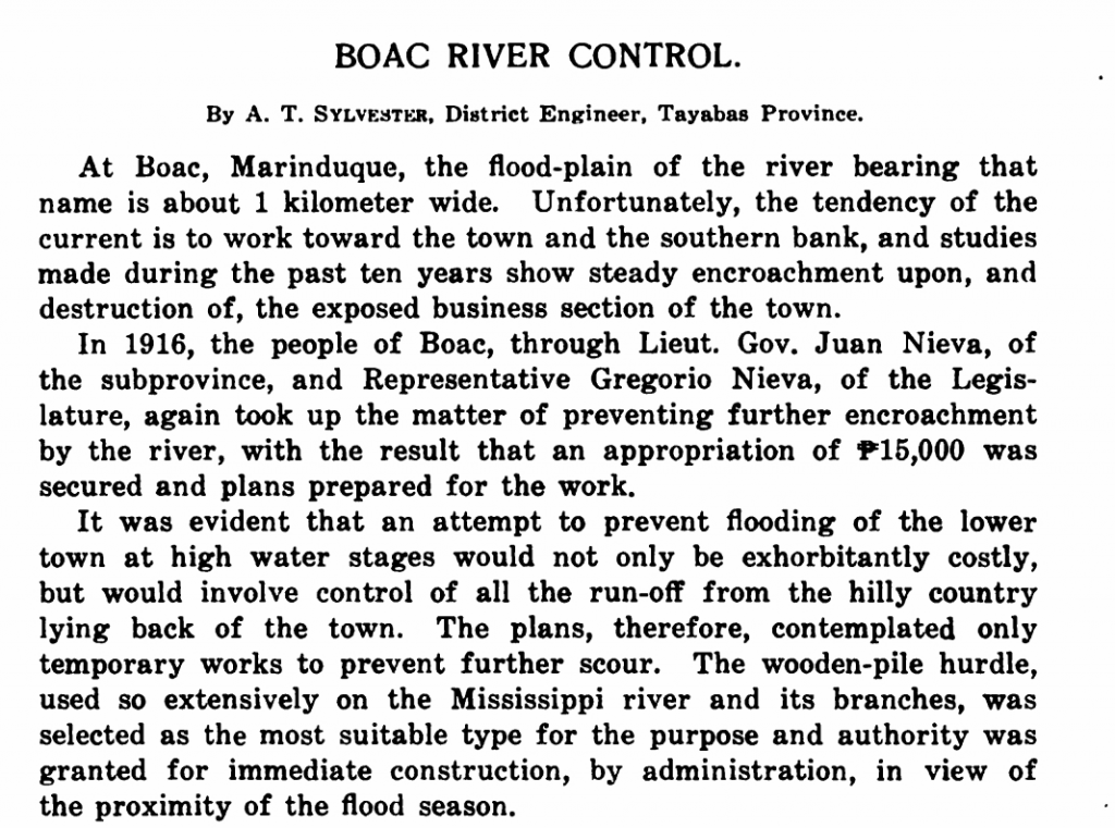
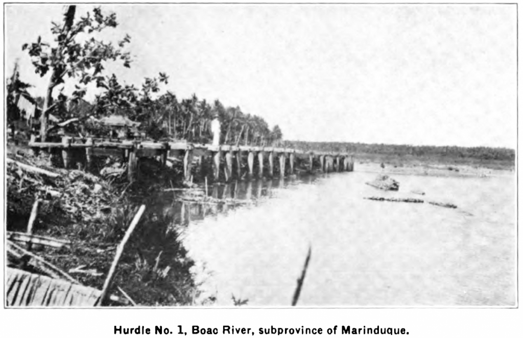
With all the concern these days about flood control projects, lets look at the 1916 attempt to control the Boac River with a 15,000 peso project.

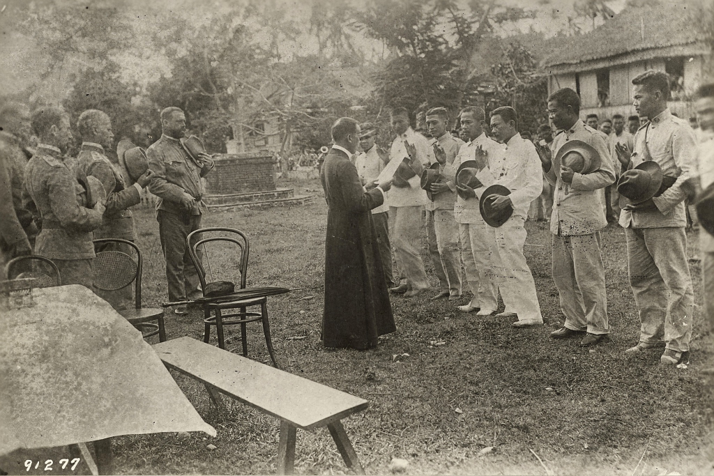
We will start the new year off with a newly discovered picture of the Maximo Abad surrender from the U.S. Archives. It provides us with a very clear face of Maximo Abad.
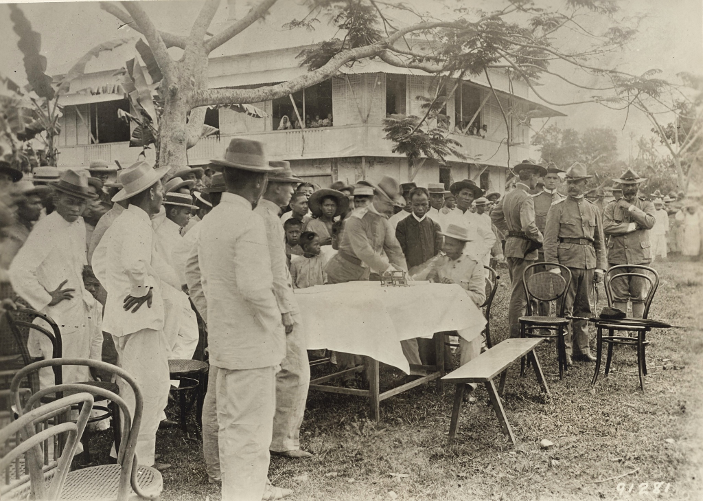
It is labeled: The priest of Boac, Marinduque, P.I. giving the oath of allegiance to Maxio Abad and some of his officers surrendering at Boac, May 1901
Officers U.S.A. – Left to right 1. Probably 1st Lt. Campbell King, 1st infantry 2. Captain H.H. Bandholtz, 2nd Inf. 3. Major Fred Smith, 1st Inf. Comdg. 4. Captain H.H. Benham, 2nd Inf.
The next photo is labeled differently from the Archives then what I have in my collection. My photo is labeled: Abad on route to surrender Camantique , Bandholtz, Abad, Roque, Matajacon, King, Castaneda, Bugarin The archives photo is labeled: Picture taken at time of Surrender of Lt. Col. Maximo Abad and party at Boac, Marinduque, P.I. May 1901, Left to Right (there is no #1) 2. Capt. H.H. Bandholtz, 2nd Infantry 3. Maximo Abad, commander of Insurrectos on Marinduqe, P.I. 4. Capt. Roque his assistant 5. Lt. Simon –(not legible) insurrecto 6. Lt. Campbell King, 1st Infantry 7. Abad’s Adj. Exactly where this photo was taken in Boac is up to speculation.

The next photo is labeled by the archives as: Maximo Abad, Insurrecto Leader, Boac, Marinduque, P.I. and officers taking oath of allegiance in Boac, Marinduque, P.I. May 1901 1. Captain H.H. Bandholtz 2. Unknown 3. 1st Lt. Campbell King, 1st Inf. 4. Major Fred Smith, 1st Inf. 5. Dr. Renn, acting Asst. Surgeon The building in the background is the present-day site of Bodettes Gift Shop. The actual signing took place in the present-day plaza. I have often wondered why no historical marker has been placed here since it marks a pivotal place in time for Marinduque.
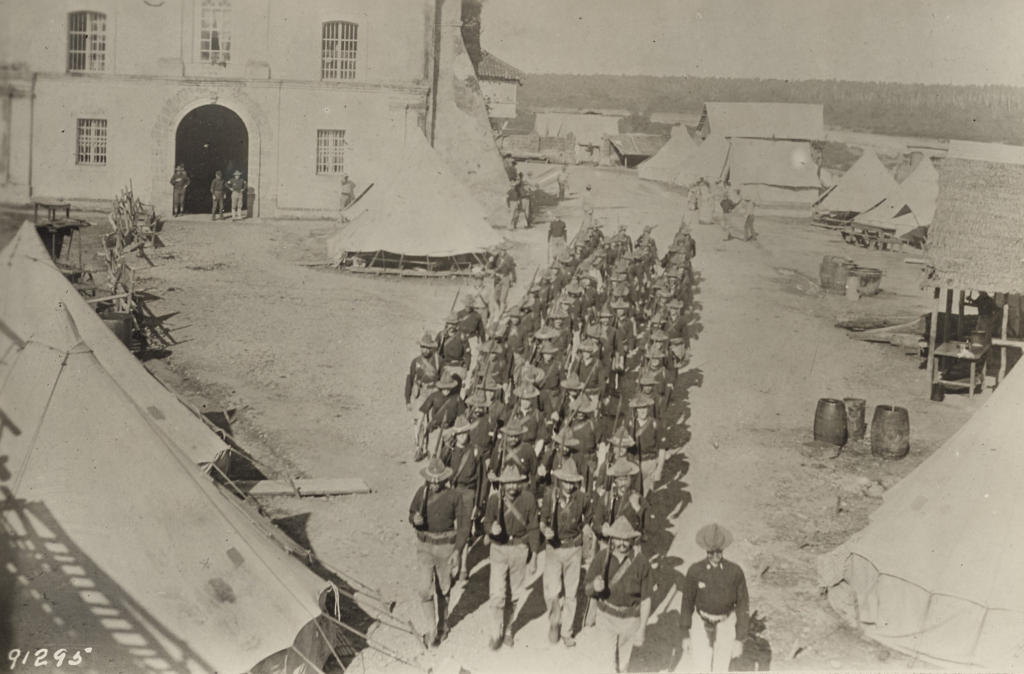
1st Lt. J.L. Hines, 2nd Infantry leaving the old convent at Boac, Marinduque, P.I. (where Hqtrs and 2 companies, 2nd Infantry were quarted) with a detachment 2nd Infantry after insurrectors. Probably February or March 1901.
Great view of the courtyard in front of the Boac church with the tents of the troops.
Lt. Hines would become a very important figure in the U.S. Army. In December 1922, Hines was assigned as Deputy Chief of Staff of the Army, and became Chief of Staff of the United States Army on 14 September 1924. In 1926, after completing his tour as Army Chief of Staff, Hines took command of the IX Corps Area in California, which he led until 1930. In 1930, Hines became commanding general of the Philippine Department. Hines retired in May 1932. He was promoted to the rank of full (4 star) general on the retired list by a Special Act of Congress on 15 June 1940.
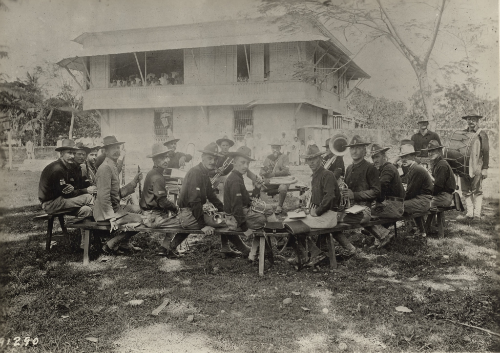
Band of the 2nd Infantry playing in the Plaza, Boac, Marinduque, P.I. 1901. Mr. Wedemeyer, Band Leader (in coat) Captain Banholtz and Dr. Renn in the window.
This appears to have been taken below the Boac church based on the wooden foot bridge in the background. This foot bridge is visible in other pictures taken of the church during that time period.